![]()


![]()
Travel tips you can trust

Why the Lemaire and
Neumayer Channels
are special
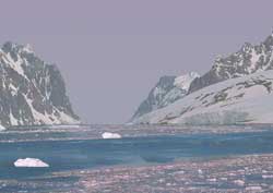
These are Antarctica's two most photographed waterways. Because they lie conveniently near each other, they often become part of the same cruise itinerary down the west coast of the Antarctica Peninsula.
 Setting
Glaciers, sheer cliffs and snow-crowned mountain peaks dramatically line the narrow Lemaire Channel and Neumayer Channel.
Calving
Glacial calving is a common occurrence along the banks of these channels.
Navigational hazard
Careful navigation is essential because the channels are interspersed with icebergs and ice floes.
Ice obstacles
Occasionally cruise boats cannot pass completely through the two channels because of temporary ice blockage.
Wildlife
Penguin colonies and basking seals dozing on rocks add to the tourist's viewing experience, as do the playful whales that sometimes accompany the cruise boats.
Zodiacs
Tours include Zodiac (small inflatable boat) trips for up close views and shore landings.
Location in Antarctica
![]() for next Lemaire Channel page
for next Lemaire Channel page
Antarctica cruise
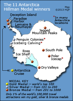
Deception Island
Dry Valleys
Iceberg Calving
Jagged Mountain Peaks
Lemaire & Neumayer Channels
Paradise Harbor
Penguin Colonies
Polar Icecap
Ross Ice Shelf
South Pole


World's Top 100 Wonders
World's Top 1000 Wonders
Site map
My credentials
About my website and criteria
Reader testimonials